|
One of the objectives in the project was to evaluate the challenges involved in the
teleoperation of an aerial vehicle in a scenario with multiple UAVs.
For example, in order to cooperate in a monitoring mission,
the human needs to pilot the helicopter far away, maybe with no full
visibility conditions. The radiocontrol pilot also needs:
- to follow the flight missions provided by the Control Centre,
- to know the positions of the UAVs involved in the mission and its own
position in this scenario,
- to have data about other elements which are relevant in a mission.
|
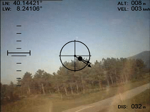
Video recorded during Lousa experiments (May 2003).
 |
In order to achieve those objectives, it is necessary to add some "special" hardware
on board the teleoperated helicopter:
- cameras and sensors to get data about helicopter attitude and environment,
- GPS devices to obtain the position of the helicopter,
- Wireless communication systems to send all this information to the
ground station to be used by the pilot.
Video recorded during Gestosa experiments (May 2003).
|
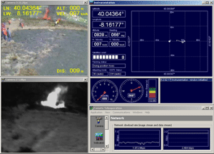
In this web page you can see some screenshots and videos from the teleoperation
interface recorded during the experiments in May 2003. This interface shows in
multiple displays:
- Graphical information about position, velocity, heading, trajectory,
target situation, etc.
- Video transmitted by the cameras on board the helicopter (infrared and visual).
- Extra data (relevant position and mission information) which is
overlayed to the images received from the cameras. This option is very useful
to help the pilot during the flight, because he has all the relevant
information integrated in a single display.
|
|