|
Terrain mapping is one of the goal missions of COMETS: it consists in providing
an update of the initially available Cartographic files of the area over which the
UAVs are operating. This update will provide up-to-date informations at an higher
resolution than initially available. Terrain mapping can satisfy the following
purposes:
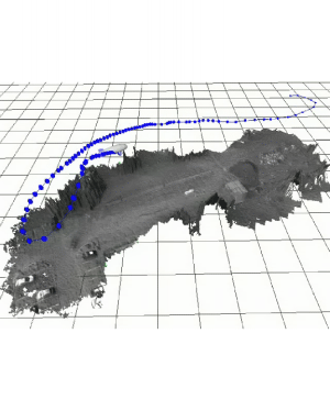
Demonstration video
 |
- It can the mission objective, e.g. to precisely assess the areas
that has been burnt after a fire occurred. Terrain mapping with a fleet of
UAVs can also be the main mission objective in various other application
contexts.
- During a fire, the built terrain map can provide the users with a
global view of the situation, allowing the evaluation of the risks, by
showing areas that may potentially burn for instance. As opposed to a
live video stream, a terrain map provides a spatially coherent view of
the scene, that memorises the areas over which the UAVs flew.
- Finally, as in most multi-robot applications, the environment model
is a basis to establish cooperation schemes.
|
|
The role of the terrain mapping with respect to the initial geographic
information system is illustrated in figure 1. In this figure, each plane
represents a type of information related to the environment. Level 1 is a
Digital Terrain Map, level 2 encodes the colours of the DTM cells. Level 1
and 2 are usually derived from aerial data (satellite or aerial imagery),
and constitute the structural, spatially consistent basis of the GIS. Levels
3 to n encode various symbolic informations: they are either derived from
the levels 1 and 2 by image processing techniques, or come from a database
build by any other mean. The role of terrain mapping is to update and refine
the first two levels of the system, whereas the role of the fire related
functions in Comets is to provide two additional symbolic information levels
(shown in red in the figure). Deriving other symbolic information from the
updated first two levels is out of the scope of COMETS.
|
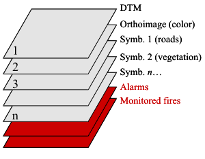
Figure 1: Symbolic illustration of the initial
Geographic Information System.
|
|